ULTRA is a process to link the urban project with city project in a single multi-scalar vision, working on the morphology and landscape of the city of Florence. Starting with the choice of two Territorial Connective Systems, some strategic sub-urban and rural areas are reinterpreted, through six meta-projects, acquiring a structuring role for urban regeneration and creating a network of common goods and accessible community services, confronting the environmental and climate challenges and the time objectives of European plans. The Florentine Plain is the result of a sequence of operations whose traces are in part still legible. Recent expansions have produced peripheral and suburban areas, leading to simplification of hillside landscapes, fragmentation of fabric, and poorly usable and inclusive places. A series of specific places to give back to the citizens and to the interconnected, permeable open spaces through an extensive planning process, prioritizing urban quality indicators.
The reading of the urban structure and landscape areas allowed us to understand in depth the relationships between the parts of the city at different scales; of relevance to the project is the porous structure, the connective tissue, which highlighted some critical relationships between the parts, such as the railway barrier, large urban nodes and undeveloped tracks, abandoned architectures.The objective of renovatio urbis is to provide ways of intervention to manage the complexity of the project, through six case studies, three in urban settings, three in natural settings.
INNOVATIVE CHARACTERS
– Intelligent site management, through coordination of planning, landscape protection and Unesco area tools.
– Two distinct context-related strategies: acupunctural in urban settings and transcalar for systems in natural settings.
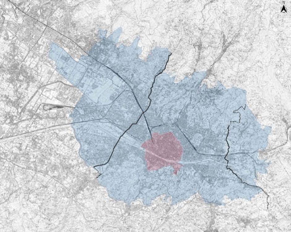
– Urban and landscape structures of Connective Systems become metropolitan thresholds at the edges of the Buffer Zone and link the consolidated historic fabric with the fabric of recent expansions from Careggi to Torregalli and with the riches of the Mensola Valley.
– Use of spatial patterns typical of historic morpho-typology: compact fabric, visual vistas and focal points, inclusive open spaces to improve walkability and sociability indices of neighborhoods.
– Accessible neighborhood polarities and services with integrated and sustainable mobility.
– New cultural product based on spatial, social relations, functional programs to develop a new semantics of public space.
RESULTS
– Increased ecological connectivity, through urban forestation operations contributing to the expansion of existing ecological networks;
– Protection and maintenance of wetlands, riparian strips and existing water bodies;
– Protection and maintenance of forested areas, valuable crops and archaeological sites;
– Reduction of impervious surfaces and increase of connective tissue portions;
– Improving microclimate and reducing heat islands, increasing micro-fauna system, improving walkability indices, accessibility and reducing residual areas;
– Elimination of architectural barriers and securing urban infrastructure and hiking trails;
– Introduction of public urban devices such as toilets, information points, integrated with spaces for listening and community participation;
– Recovery of strategic areas and definition of a system of accessible, identity and interconnected places through operations on the urban fabric;
– Reduction of built-up land, recovery and remediation of sites potentially harmful to humans and the environment.
Through the creation of a dialogue that ensures continuity between past and present, ULTRA is able to mark a concrete transition to a sustainable and efficient future by placing side by side an integrated approach that meets SDG #13 goals with Florence’s strong historical and landscape component and is its only starting point, which is based on education, innovation, and smart use of our precious resources.
Pilot projects represent a chance to take direct, long-term action to combat climate change by working with the resources of places for a future that reduces the risk of environmental disasters while safeguarding the community and the environment. The design of ULTRA is a manifesto for a car-free city and limiting carbon emissions; ULTRA is caring for streams, nature and wildlife, protecting biodiversity and increasing ecological networks; ULTRA is awareness, of the negative aspects related to impermeable soils, building sprowl, and social and economic degradation; ULTRA is a tool, through which to rebuild a dense and rich fabric of 360-degree relationships and achieve global goals, reading diversity as a valuable resource and diverse spatial resources as a complementary wealth.
FUTURE DEVELOPMENTS
ULTRA is a suggestion to reread the variable conditions of the urban structure and investigate the connection mechanisms of architecture in the relationship of juxtaposition with the existing fabric, acting at the intermediate scale of the urban project.
It accommodates the ongoing transformations of the Florentine metropolitan area and coordinates with the tools, through the involvement of agencies and administrations.
A coordinated and participatory process would make the implementation process smooth, achieving the goals of the strategic vision (PSM2030, UNESCO Buffer Zone Management Plan). Expanding research and employing specific figures and state-of-the-art tools for project management and evaluation would be useful.
This approach prefers the public dimension to the private sphere and teaches the community to care again for a city rich in quiet resources, becoming an active participant for an ultra-competitive and accessible Florence.